
Research
PUBLICATIONS
https://doi.org/10.25916/sut.30163783
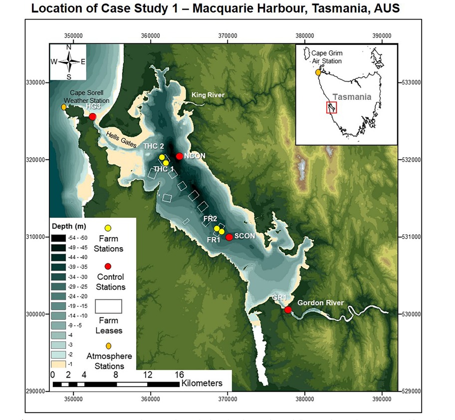
Aquaculture | Biogeochemical CyclingDissolved oxygen and nitrous oxide dynamics in an Australasian fjord- like estuary and its augmentation by marine aquaculture
Abstract
This body of research investigates dissolved oxygen (DO) and nitrous oxide (N₂O) dynamics in Australasian estuaries. We found that in systems like Macquarie Harbour, water-column oxygen consumption, driven by a combination of organic matter respiration and nitrification, can be the major driver of hypoxia in isolated sections of the system, with aquaculture acting as, localized accelerator of both DO and N2O activity. The study highlights hydrodynamic drivers, from local and meso-scale processes, can affect the formation of hypoxia and subsequently affect N2O formation and depletion. The study also highlights that these estuaries function as both sources and sinks for N₂O depending on river flow.
Ocean & Coastal Management Volume 50, 2007 - Issues 1–2
https://doi.org/10.1016/j.ocecoaman.2006.03.013
PolicySabah shoreline management plan (Borneo, Malaysia) : Ecosystems and pollution
Abstract
The management of the coastline around Sabah (Borneo, Malaysia) faces numerous conflicting interests from the public, private and industry groups. The public demands socio-economic growth, sustainable development and preservation of natural resources while the private sector and industry demand local coastal protection and often reckless development. Subsequently, there are numerous multi-disciplinary conflicts across user groups, over the use of coastal resources. To resolve these issues the creation of a management plan for Sabah’s coastline has been initiated. A baseline was established from historical investigations, data collection and using a combination of visual inspections and photos. Understanding of the physical, chemical and biological processes involved as well as the dynamics of the integrated processes and a holistic impact assessment is also required. To do so numerical models were used to integrate available information and knowledge and to hind-cast and now-cast conditions and predict the consequences of different development scenarios. In some cases the models results needed further detailed analysis in combination with specific knowledge on local habitats to determine the impacts. The focus of the paper is on the integration of information, but some details are also given on the important conflicts and habitat threats.
Earth Surface Processes and Landforms Volume 31, 2006 - Issue 6
https://doi.org/10.1002/ESP.1340
Geology | Ocean ProcessesWave energy and clast transport in eastern Tasman Bay, New Zealand
Abstract
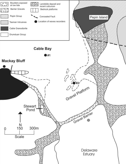
Coarse-gravel beaches are common features along the eastern margin of Tasman Bay, at the north end of South Island, New Zealand. Although these features have traditionally been interpreted as spits, contemporary incident wave energy appears too small to transport boulders and cobbles persistently along the beaches and platforms by longshore drift. An alternative explanation suggests that boulder beaches are essentially derived in situ from resistant bedrock, which lies seaward and was buried by gravel during the Holocene sea level rise. Wind, wave and clast size data from Cable Bay and the Nelson Boulder Bank were used to resolve this problem. Wave and wind data indicate that waves reaching these areas are derived locally in Tasman Bay, and are limited in size and energy. Hindcasting predicts a 4·7 m wave could propagate from Tasman Bay. However, during Cyclone Yalli, the most intense storm in nearly 40 years of wind records, the largest wave measured in the nearby area of Cable Bay was only 2·7 m high. Maximum orbital velocity on the seabed beneath a 4·7 m is calculated to be 2·9 m s−1, which cannot initiate transport of clasts greater than 0·15 m in diameter. Clasts on the gravel platforms have average diameters greater than this, but some clasts may be as large as 1·0 m in diameter. By comparison, a swash run-up method predicts that a wave 4·7 m high can transport clasts no larger than 0·3 m in diameter. These data and approximate calculations strongly suggest that the present wave environment in eastern Tasman Bay is not capable of consistently transporting clasts on the boulder platforms by longshore drift. Reduced sea levels in the pre-Holocene period would further reduce wave energies available in Tasman Bay. Copyright © 2006 John Wiley & Sons, Ltd.
IEEE Journal of Oceanic Engineering, Volume 30, 2005 - Issue 1
https://doi.org/10.1109/JOE.2004.841388
AquacultureAcoustical and sedimentological characterization of substrates in and around sheltered and open-ocean mussel aquaculture sites and its bearing on the dispersal of mussel debris
Abstract
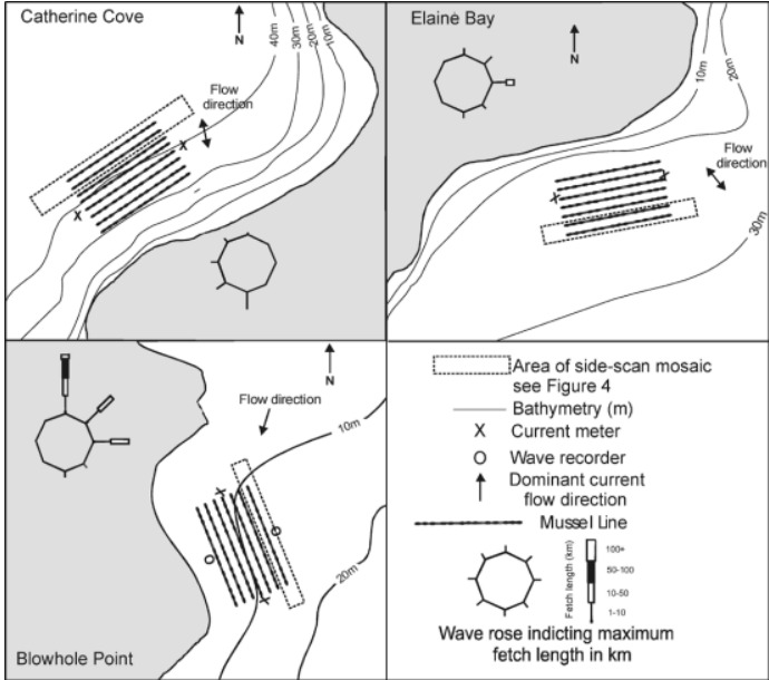
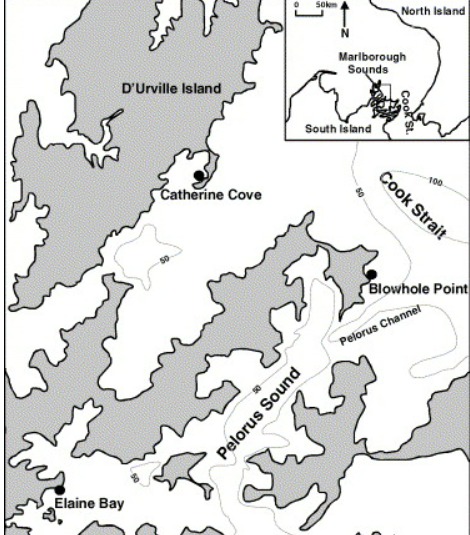
Side-scan sonar, camera observations, and sediment sampling are used to determine the seabed dispersal of mussel debris at three aquaculture farm sites in sheltered to exposed environments in the Marlborough Sounds, New Zealand. At the two sheltered farm sites, side-scan sonagraphs reveal high acoustic backscatter beneath culture sites and low backscatter in the immediate surrounds. This suggests a sharp contrast in seabed material around the edges of the farm. Photography and sediment samples reveal farms are underlain by mounds of shells with biodeposits infilling intershell voids and forming a veneer over entire mounds. In contrast, the surrounding seabed is naturally sedimented soft mud. Sediment from beneath the farms had total organic contents of 8%-19% decreasing sharply to natural levels of 4%-7%, 30 m from the farm’s boundaries. The third site is exposed to energetic waves and currents, and exhibits low acoustic backscatter zones beneath the farm. Photographs show the seabed is predominantly clean sand with only scattered clumps of shells and no biodeposits visible. Sediments are typical of the natural setting. This lack of mussel debris indicates that there is sufficient energy to transport and dissipate the shell and biodeposits over a wide area with little impact on the natural sediment.
Aquacultural Engineering Volume 33, Issue 3, September 2005, Pages 192-213
https://doi.org/10.1016/J.AQUAENG.2005.01.002
AquacultureDeposition beneath long-line mussel farms
Abstract
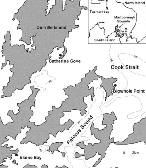
Current meter data, biodeposit settling velocity, turbulent diffusivity and water depth were combined to model the initial depositional distribution of faecal and pseudofaecal pellets at three aquaculture farm sites in sheltered to exposed environments in the Marlborough Sounds. Model results were compared with seabed sediment samples collected at each site. At the sheltered sites, comparison of the modelled dispersal pattern and seabed identification of mussel biodeposits using sedimentological data indicated a very close association. Both were found to reduce to natural levels approximately 30–50 m from the farm site. Such similarity between the model and observed distribution of the mussel biodeposits suggested that, once deposited on the seabed, the biodeposits remain immobile due to the low hydrodynamic energy of the two sites. In contrast, the exposed site had only a poor correlation between the dispersal model and identification of mussel biodeposits on the seabed. The dispersal model indicates that the majority of mussel biodeposits initially accumulate within 50 m of the farm. However, observations found no sign of any mussel biodeposits in sediment beneath or up to 200 m from the farm boundary. This lack of biodeposits indicates that there is at times sufficient energy to re-suspend mussel biodeposits and to disperse these deposits over a wide enough area thereby leaving little impact on the natural sediment.
Marine Environmental Research Volume 57, 2004 - Issue 5
https://doi.org/10.1016/J.MARENVRES.2003.11.003
Aquaculture | Ocean ProcessesEffect of biodeposits from mussel culture on macroinvertebrate assemblages at sites of different hydrodynamic regime
Abstract
The present study examined for differences in macroinvertebrate assemblage composition inside and outside of mussel farm sites experiencing different hydrodynamic regimes. Multivariate analysis revealed that there were significant differences in macroinvertebrate assemblage composition (averaged across seasons) between samples taken inside and outside of the two relatively low energy sites, whilst no such difference was observed for the relatively high energy site. Taxa that best discriminated between the dissimilarities observed in macroinvertebrate assemblage composition inside and outside farms were principally polychaetes (more abundant inside) and ophiuroids (more abundant outside). Sediment total organic matter and number of mussel shells were the parameters that best explained the difference in macroinvertebrate assemblage observed at the two relatively sheltered farm study sites. No taxa or environmental variables were particularly good at discriminating or explaining differences observed inside and outside the relatively high energy farm site. The present study indicates there is a relationship between the hydrodynamic regime of a farm site, organic enrichment of seabed sediments by mussel biodeposits, and a subsequent modification of the macroinverebrate assemblages. This finding has implications for the site selection of mussel farms in coastal environments.
Biogeosciences, 19, 3131–3150, 2022
https://doi.org/10.5194/bg-19-3131-2022
Ocean Processes | Biogeochemical CyclingThe influence of mesoscale climate drivers on hypoxia in a fjord-like deep coastal inlet and its potential implications regarding climate change: examining a decade of water quality data
Abstract
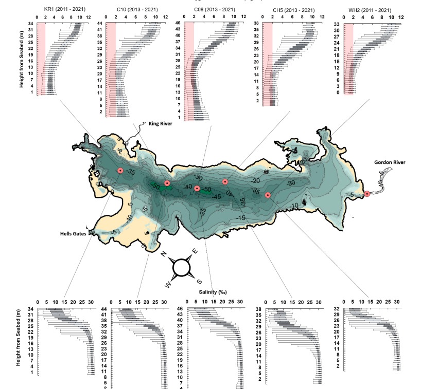
Deep coastal inlets are sites of high sedimentation and organic carbon deposition that account for 11 % of the world’s organic carbon burial. Australasia’s mid- to highlatitude regions have many such systems. It is important to understand the role of climate forcings in influencing hypoxia and organic matter cycling in these systems, but many such systems, especially in Australasia, remain poorly described. We analysed a decade of in situ water quality data from Macquarie Harbour, Tasmania, a deep coastal inlet with more than 180 000 t of organic carbon loading per annum. Monthly dissolved oxygen, total Kjeldahl nitrogen, dissolved organic carbon, and dissolved inorganic nitrogen concentrations were significantly affected by rainfall patterns. Increased rainfall was correlated to higher organic carbon and nitrogen loading, lower oxygen concentrations in deep basins, and greater oxygen concentrations in surface waters. Most notably, the Southern Annular Mode (SAM) significantly influenced oxygen distribution in the system. High river flow (associated with low SAM index values) impedes deep water renewal as the primary mechanism driving basin water hypoxia. Climate forecasting predicts increased winter rainfall and decreased summer rainfall, which may further exacerbate hypoxia in this system. Currently, Macquarie Harbour’s basins experience frequent (up to 36 % of the time) and prolonged (up to 2 years) oxygen-poor conditions that may promote greenhouse gas (CH4, N2O) production altering the processing of organic matter entering the system. The increased winter rainfall predicted for the area will likely promote the increased spread and duration of hypoxia in the basins. Further understanding of these systems and how they respond to climate change will improve our estimates of future organic matter cycling (burial vs. export).
Discover Oceans Volume 2, 2025 - Article 18
https://doi.org/10.1007/s44289-025-00058-5
Mangroves | Ocean CarbonQuantifying mangrove export of dissolved organic carbon on large scales and at fine resolution: a review of current technologies and the path forward
Abstract
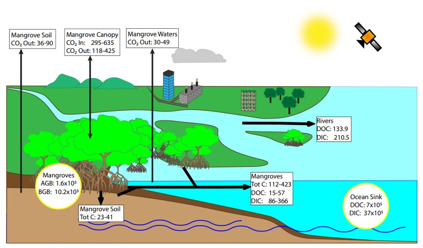
Mangroves are carbon dense forests that are threatened by human driven factors. Their ability to sequester carbon can play a key role in meeting climate targets like the Paris Climate Agreement and the United Nations Sustainable Development Goals. In addition to sequestration, mangroves are significant sources of carbon to the ocean sink, which has implications for global carbon budgets. Mangrove carbon export is estimated to be equivalent to about 4% of yearly anthropogenic CO2 emissions. Currently, most estimates of global mangrove dissolved organic carbon (DOC) export are scaled from local analyses. However, mangrove ecosystems are dynamic and local analyses alone are not sufficient for accurate quantification of DOC export. Studies of mangrove DOC export need to expand spatial and temporal scales and refine temporal resolution. Technologies like advanced in-situ sampling, laboratory methods, remote sensing, modelling and machine learning can help to achieve this, but they are underutilised in mangrove DOC export research. In this review we explore the current state, existing and emerging technologies, and future needs for the study of mangrove DOC export.
npj Ocean Sustainability 5, Article number: 8 (2026)
https://doi.org/10.1038/s44183-025-00180-z
Aquaculture | Biogeochemical CyclingObservations of mariculture associated N2O loss: a need for system specific studies
Abstract
Aquaculture’s contribution to global N2O emissions is poorly constrained and often reliant on supply chain/industrial emissions/life-cycle analyses which generalise system responses to farm-derived inputs and contain few examples of direct measurements made in situ. Among the studies that do report aquaculture associated N2O emissions the focus has been on pond culture and wetlands systems rather than open marine systems. Our study examined the effects of open system aquaculture culture on water column N2O cycling in two hydrodynamically contrasting southern hemisphere systems: the heavily stratified Macquarie Harbour, Tasmania, Australia and the semienclosed but well-mixed Big Glory Bay, New Zealand. Significant, but localised, N2O undersaturation was observed under the active salmon farm in the heavily stratified Macquarie Harbour during the peak feeding season, but not under fallowed salmon farms or the non-farmed areas. This was observed in a low-oxygen but not anoxic water column. Water column N2O was either in equilibrium with the atmosphere or supersaturated in all other instances. In Big Glory Bay N2O undersaturation was observed during winter and spring sampling surveys that generally persisted across the bay and resulted in removal of atmospheric N2O. The specific mechanisms of N2O loss are still uncertain but is likely driven by a combination of particle associated denitrification activity in farm waste plumes, denitrification/DNRA in sediments and on the detritus covered mussel shells and lines. Overall, this study demonstrates that industry impacts to N2O cycling can include loss dynamics which have previously been unreported. Therefore, global estimates of N2O emissions from aquaculture may be significantly overestimated.
Coastal Management Volume 51, 2023 - Issue 1
https://doi.org/10.1080/08920753.2023.2148860
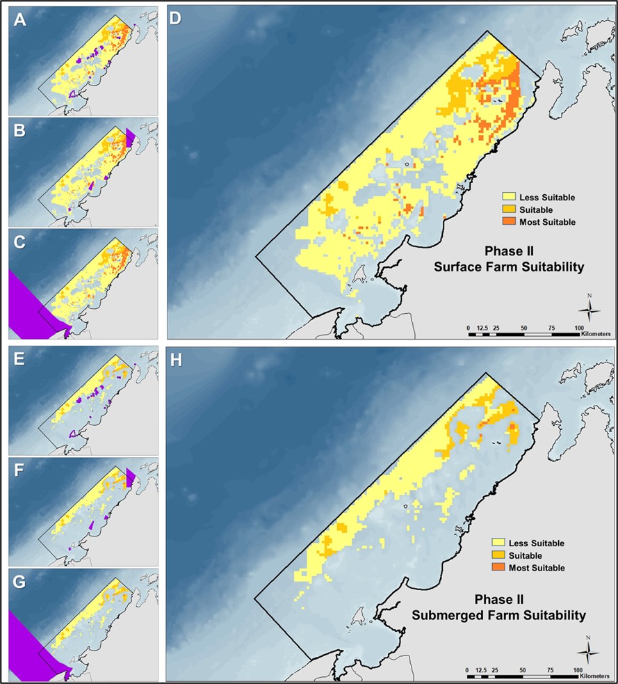
MCDM | AquacultureMarine Finfish Aquaculture Planning Using MCDM and Numerical Modelling Tools to Aide Industry Expansion along the North Borneo West Coast
Abstract
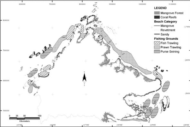
Site selection is the foundation of sustainable finfish culture, and in the tropics, there are vast offshore areas where this is needed. This study is the first to identify areas for marine finfish culture along the North Borneo West Coast using outputs from hydrodynamic modeling coupled with GIS and Multiple-Criteria Decision Making Analysis. Site selection criteria included: water depth, current speed, significant wave height, sensitive habitats, reported fishing grounds, government-based exclusion zones, oil & gas consents, and navigation routes. Of an initial 2.55 million ha, 1.05 million ha was eliminated from consideration based on physical characteristics alone. Of the 1.50 million ha identified to satisfy physical and hydrodynamic criteria for surface-oriented farms, a further 0.06 million ha was eliminated due to sensitive habitat and government exclusion zones. The remaining 1.44 million ha was found suitable for surface pen farming and 0.61 million ha for submerged pen farming. Much of this potential area is shared with capture fishery grounds, oil & gas consents, and navigation routes that will require further assessments (e.g. EIAs) to determine specific impacts to those industries. Those areas not in multi-user conflict makes up 0.57 million ha and 0.28 million ha for surface and submerged farms respectively.
Aquacultural Engineering Volume 93, May 2021, 102154
https://doi.org/10.1016/j.aquaeng.2021.102154
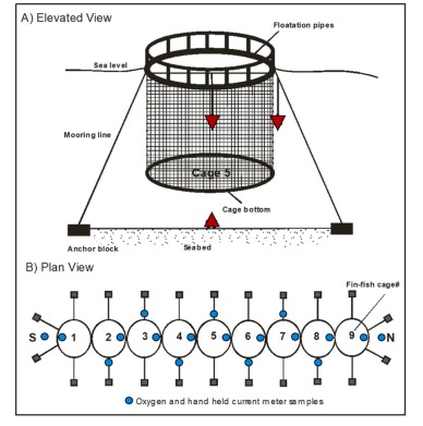
Aquaculture | Ocean ProcessesHydrodynamic implications in and around a caged finfish farm and its implications on the dispersal of farm debris
Abstract
One of the key factors in determining the accumulation of sediment and soluble nutrients within a lease is water movement. Water masses entering and leaving the farm determine the finfish ecosystem interaction. Understanding the hydrodynamic interaction with the farm is therefore key to understanding the potential ecological effects of individual farms. In addition, finfish farms are now being proposed in exposed offshore environments and have caused concern regarding their potential down stream impacts on currents and wave climate. Seven current meters, oxygen probes and CTD were deployed to examine the hydrodynamic interactions inside and outside a 270 m long Salmon farm in Newfoundland, Canada. Current meter results indicate that the finfish farm cages have a clear shadowing effect on the currents. Currents upstream were found to be considerably faster than those recorded downstream during the sampling period. Current speeds inside the farm were also found to be considerably slower than those found outside of the farm especially during high flow events. In situ observations of currents were found to be similar to those predicted by previous CFD and hydrodynamic modelling studies. Modeling was also undertaken to calculate the energy lost as currents enter and leave a series of fish cages. In comparison to the observed flow the model compares relatively well. Flow recorded downstream of the farm was observed to be in the range predicted by the model as was the flow recorded inside and outside the cages. Current speed downstream of the farm is clearly affected by farm orientation which has important implications for the dispersal of farm debris. Average oxygen saturation within the cages over the 5 day sampling period was 80.2 %± SD 5.7 %, compared to nearly 100 %, 20 m and 50 m from the farm site. Orientation of the farm may play some part in determining the location and amount of oxygen depletion within the farm. The farm also acts to push water from deeper in the water column up into the cages which has implications for farms situated in heavily stratified environments.
Ocean & Costal Management, 211 (2021) 105781
http://doi.org/10.1016/j.ocecoaman.2021.105781
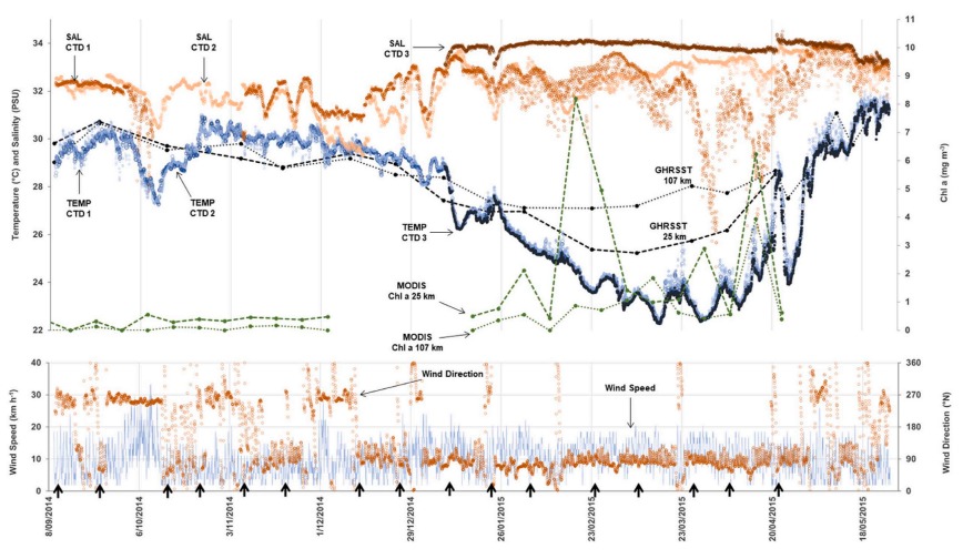
Aquaculture | Ocean ProcessesCoastal upwelling along the west coast of Sabah and its impact on coastal aquaculture management
Abstract
The aquaculture industry in Malaysia is currently growing at nearly 9 percent per year and is generating more than 250,000 tons of production per annum. However, little commercial scale aquaculture is present along thewest coast of the state of Sabah. Few if any studies have been conducted to investigate aquaculture site suitability along the west coast of Sabah and the wider west coast of Borneo from an environmental or coastal management perspective. To determine the site suitability for marine aquaculture and other coastal resource users there needs to be an improved understanding of the physical, chemical, and biological characteristics of the coastal environment. One year of data collection including the long-term deployment of Conductivity, Temperature and Depth (CTD) sensors, and bi-monthly water column and seabed sediment sampling was undertaken to provide an indication if the coastal waters between Kota Belud and Kudat are suitable for marine aquaculture purposes. The site provided an analogy for much of the west coast of Borneo, especially the west coast of Sabah, due to similar oceanographic drivers in the region. Results indicated that during the NE monsoon period there is dramatic decrease in water temperature due to the upwelling of cold dense nutrient rich water onto the west coast of Sabah’s continental shelf from deeper offshore areas of the South China Sea. This large change in temperature will likely rule out the potential commercial marine grow out of such species as Asian Seabass and perhaps Tropical Spiny Lobsters. Other species such as Cobia, Grouper and Snapper which have a wider tolerance for temperature change will likely be suitable but at times will be stressed due to magnitude of the observed changes. Such observations have ramifications in regard to site suitability for future resource consent applications for open ocean and coastal aquaculture along the west coast of Borneo. In summary the study highlights how physical processes can impact on resource use and development in a coastal setting.
Biogeosciences, 21, 5613–5637, 2024
https://doi.org/10.5194/bg-21-5613-2024
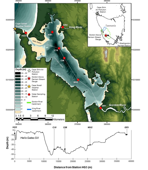
Biogeochemical CyclingNitrous oxide (N2O) in Macquarie Harbour, Tasmania
Abstract
Fjord-like estuaries are hotspots of biogeochemical cycling due to their steep physicochemical gradients. The spatiotemporal distribution of nitrous oxide (N2O) within many of these systems is poorly described, especially in the Southern Hemisphere. The goals of this study are to describe the spatiotemporal distribution of N2O within a Southern Hemisphere fjord-like estuary, the main environmental drivers of this distribution, the air–sea flux of N2O, and the main drivers of N2O production. Sampling surveys were undertaken in Macquarie Harbour, Tasmania, to capture N2O concentrations and water column physicochemical profiles in winter (July 2022), spring (October 2022), summer (February 2023), and autumn (April 2023). N2O samples were collected from middle water depths in the ocean (5 m), minor river (1 m) endmembers, the major river (10 m) endmember at 2 m from the bottom, and at five depths through the water column at four stations within the main harbour body.
Results indicate that N2O was consistently supersaturated (reaching 170 % saturation) below the system’s freshwater lens where oxygen concentrations are often hypoxic but infrequently anoxic. In the surface lens, levels of N2O saturation vary with estimated river flow and with proximity to the system’s main freshwater endmember. The linear relationship between apparent oxygen utilisation and 1N2O saturation indicates that nitrification is the process generating N2O in the system. When river flow was high (July and October 2022), surface water N2O was undersaturated (as low as 70 %) throughout most of the harbour.
When river flow was low (February and April 2023) N2O was observed to be supersaturated at most stations. Calculated air–sea fluxes of N2O indicated that the system is generally a source of N2O to the atmosphere under weak river flow conditions and a sink during strong river flow conditions. The diapycnal flux was a minor contributor to surface water N2O concentrations, and sub-halocline N2O is intercepted by the riverine surface lens and transported out of the system to the ocean during strong river flow conditions. In a changing climate, western Tasmania is expected to receive higher winter rainfall and lower summer rainfall, which may augment the source and sink dynamics of this system by enhancing the summer and autumn efflux of N2O to the atmosphere.
This study is the first to report observations of N2O distribution, generation processes, and estimated diapycnal and surface N2O fluxes from this system.
Biogeosciences, 19, 3131–3150, 2022
https://doi.org/10.5194/bg-19-3131-2022
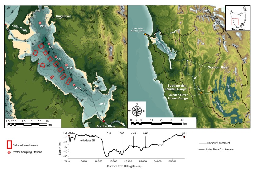
Ocean Processes | Biogeochemical CyclingThe influence of mesoscale climate drivers on hypoxia in a fjord-likedeep coastal inlet and its potential implications regarding climatechange: examining a decade of water quality data
Abstract
Deep coastal inlets are sites of high sedimentation and organic carbon deposition that account for 11 % of the world’s organic carbon burial. Australasia’s mid- to highlatitude regions have many such systems. It is important to understand the role of climate forcings in influencing hypoxia and organic matter cycling in these systems, but many such systems, especially in Australasia, remain poorly described.
We analysed a decade of in situ water quality data from Macquarie Harbour, Tasmania, a deep coastal inlet with more than 180 000 t of organic carbon loading per annum. Monthly dissolved oxygen, total Kjeldahl nitrogen, dissolved organic carbon, and dissolved inorganic nitrogen concentrations were significantly affected by rainfall patterns. Increased rainfall was correlated to higher organic carbon and nitrogen loading, lower oxygen concentrations in deep basins, and greater oxygen concentrations in surface waters. Most notably, the Southern Annular Mode (SAM) significantly influenced oxygen distribution in the system. High river flow (associated with low SAM index values) impedes deep water renewal as the primary mechanism driving basin water hypoxia. Climate forecasting predicts increased winter rainfall and decreased summer rainfall, which may further exacerbate hypoxia in this system.
Currently, Macquarie Harbour’s basins experience frequent (up to 36 % of the time) and prolonged (up to 2 years) oxygen-poor conditions that may promote greenhouse gas (CH4, N2O) production altering the processing of organic matter entering the system. The increased winter rainfall predicted for the area will likely promote the increased spread and duration of hypoxia in the basins. Further understanding of these systems and how they respond to climate change will improve our estimates of future organic matter cycling (burial vs. export).
Estuarine, Coastal and Shelf Science, Volume 246, 5 November 2020, 107016
https://doi.org/10.1016/j.ecss.2020.107016
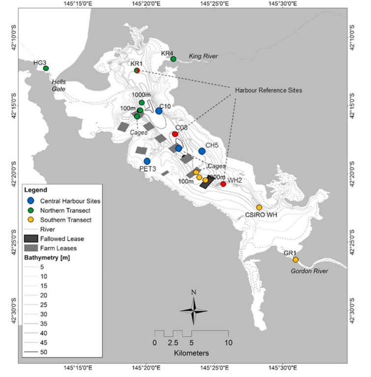
Ocean Processes | Biogeochemical CyclingDissolved oxygen consumption in a fjord-like estuary, Macquarie Harbour, Tasmania
Abstract
Microbial respiration of organic matter (OM) is a key driver of deoxygenation and hypoxia. In fjord-like estuaries with established aquaculture industries understanding drivers of oxygen demand, and the relative importance of different drivers, is crucial for improving fish farming management in those systems. We designed a study to examine patterns of pelagic oxygen demand (POD) in a fjord-like estuary on the west coast of Tasmania, Macquarie Harbour, and relate those observations to physical forcings and major OM sources. Monthly water column sampling and bottle incubation experiments were conducted from June to November 2017. Water was collected throughout the harbour including river and oceanic endmembers as well as transects leading away from fish
farms. Water was incubated from 4 different depths spanning the surface water to the seabed. Regression modelling was used to examine the relationship between POD, riverine OM loading, proximity to fish farms and the major system endmembers, depth, harbour region, concentration of dissolved oxygen, and month. POD
reached rates as high as 0.108 mg L− 1 hour− 1 with the greatest POD observed above the halocline and during high river flow/OM loading months. Regression modelling showed that important drivers of POD are spatially specific along vertical and longitudinal gradients. The importance of riverine OM loading waned with depth primarily due to mixing dynamics of dissolved organic carbon across the halocline. Proximity to fish farms was an important but localized explanatory variable for POD in the halocline and basin waters, but not a significant driver of POD compared to the Gordon River. Based on the POD rates observed in this study, hypoxia can be established in less than 9 days in the basin waters and is primarily driven by pelagic oxygen sinks (95%–98%), not sediment sinks. It is crucial that aquaculture management accounts for natural, and/or preexisting, variation in endmember OM loading and its effect on DO dynamics, in these systems.
Borneo Journal of Marine Science and Aquaculture, Volume: 01, December 2017, 75 - 79
https://doi.org/10.51200/bjomsa.v1i.995
Methods DevelopmentSimple quality control technique to identify dissolved oxygen diffusion issues with biochemical oxygen demand bottle incubations
Abstract
Stratified estuaries are home to expanding aquaculture activities whose ecological footprints can be observed through trends in microbial community respiration in the water column. Bottle incubations are widely used to measure water column communityrespiration in marine and freshwater ecosystems by measuring the flux of dissolved oxygen occurring in the bottle over a period of time. When in situ dissolved oxygen (DO) concentrations are markedly different than DO concentration of the
incubation medium the potential for diffusion of oxygen across the bottle opening is great and may be especially pronounced in strongly stratified systems with relatively low rates of pelagic oxygen consumption. We incubated 60 Biochemical Oxygen Demand (BOD) bottles filled with sterilized water with DO concentrations ranging from 2.51 mg O2 L-1 to 10.03 mg O2 L-1 for 24 hours in a temperature controlled water bath. There was a significant relationship when DO flux was set as a function of initial DO (DO Flux = -0.0017x + 0.0085, r2 = 0.72, p < 2.2 e-16). DO fluxes ranged from -0.012 mg O2 L-1 hour-1 to 0.005 mg O2 L-1 hour-1
for bottles incubated with initial DO ranging from 10.03 mg O2 L-1 to 3.31 mg O2 L-1, respectively. These results suggest that diffusion across the ground glass seal of BOD bottles is possible and that extra precaution through parallel diffusion controls should be considered when measuring pelagic respiration using BOD bottle incubations in systems with relatively low or relatively high in situ DO concentrations.
Journal of Marine Systems 199 (2019) 103226
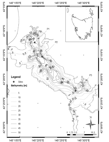
Ocean ProcessesDrivers of deep water renewal in Macquarie Harbour, Tasmania
Abstract
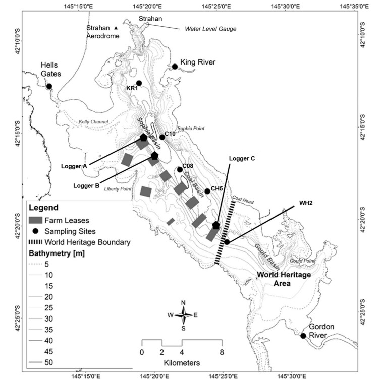
Macquarie Harbour is a fjord-like estuary located on the west coast of Tasmania and is home to a growing aquaculture industry. The harbour is oriented with the mouth on its north west end and two main tributaries located on its northeast and southeast ends. Both of the system’s major tributaries have hydroelectric power
schemes controlling catchment discharge into the harbour. The harbour has a history of low oxygen concentrations and the bottom water is often oxygen poor. No study to date has described the underlying mechanisms of deep water renewal and oxygenation in the system.
Approximately 5 years of data from monthly dissolved oxygen, salinity, and temperature profiles, located throughout the harbour, and 3 continuous logger stations was analysed with water level and meteorological data. These data were used to describe the drivers of water level and deep water oxygen renewal in the system.
This study provides a first order estimate of the net mass of dissolved oxygen entering via these marine water intrusion events.
Data analysis indicates that deep water renewal appears to occur episodically, with only 2 significant events recorded over a 5 year period, though a number of smaller events were also recorded on a monthly basis. The largest events were observed during winter and late autumn and are associated with strong north westerly winds
and a sudden drop in atmospheric pressure. The drop in pressure results in an increase in water level that allows marine water to enter the harbour via the mouth. The north westerly winds act to push surface water to the southern end of the harbour allowing more water to flood over the sill into the Sophia basin.
Analysis of oxygen, temperature and salinity logger data indicates that larger renewal events create water column instabilities which can provide a potential threat to the salmon aquaculture industry situated in the harbour. The frequency of renewals also has implications on the standing oxygen concentrations in the harbour,
with fewer events likely resulting in greater periods of hypoxia in the bottom and mid water column.